Bedford Borough: Planning, Regeneration & Development
Intelligence Report
Key Metrics at a Glance
Universal Studios Great Britain (Kempston Hardwick)
Status: Planning permission granted — December 2025
The UK Government granted planning permission via a Special Development Order (SDO) on 16 December 2025. Construction enabling works began immediately; the SDO came into force early 2026. Full construction underway July 2026. Projected opening: 2031.
Site boundary & four-zone structure
| Zone | Location | Primary uses | Notes |
|---|---|---|---|
| Core Zone | Central–south of site | Theme park lands, rides, attractions, hotel accommodation | James Bond, Paddington, Lord of the Rings, Minions rumoured as IP |
| Lake Zone | North of core, former clay pits | CityWalk-style retail, dining, entertainment, lakeside leisure | Existing lakes retained as centrepiece feature |
| Buffer/Ecology Zone | Southern and eastern edges | Ecological reserve, green infrastructure, public open space | Permanent open space commitment — Kempston Hardwick moated site protected |
| Transport Hub Zone | Western edge, A421 frontage | Multi-modal transport hub, car parking, new rail stations, coach drop-off | New station on West side; replaces Stewartby & Kempston Hardwick stations |
Affected roads & streets
| Road / Street | Impact type | Status |
|---|---|---|
| A421 (Black Cat to Bedford) | New dedicated slip roads, widening, junction improvements | Committed in SDO |
| Broadmead Road | Permanent signalisation at Woburn Rd junction; width concern raised in EGM | In design |
| Manor Road (east) | Partial use for early enabling works; possible closure during peak construction | Agreed in principle |
| Ampthill Road | Construction vibration impact zone — moderate adverse during build | Mitigation required |
| Green Lane | Diversions in place for underground services survey | Active July 2026 |
| Woburn Road | Junction signalisation, construction traffic routing | Permanent change |
| Bedford Road (Stewartby) | Visitor approach route, bus services, possible park-and-ride link | Under review |
Bedford Town Centre Regeneration
Town Centre Masterplan — Allies & Morrison (2023)
The One Public Estate Transforming Bedfordshire masterplan, designed by Allies & Morrison, sets the vision for town centre growth. Key themes: riverside activation, station quarter transformation, Greyfriars residential regeneration, and strengthening Bedford High Street / Harpur Centre. The masterplan was prepared as part of the Bedford Local Plan 2040 evidence base and informed the Town Deal programme.
- Vision: "Bedford — a place to live, work, shop, learn and explore"
- Target: significant new homes, workspace, and public realm within the urban area
- Linked to: East West Rail arrival, Greyfriars SDO, Midland Road corridor
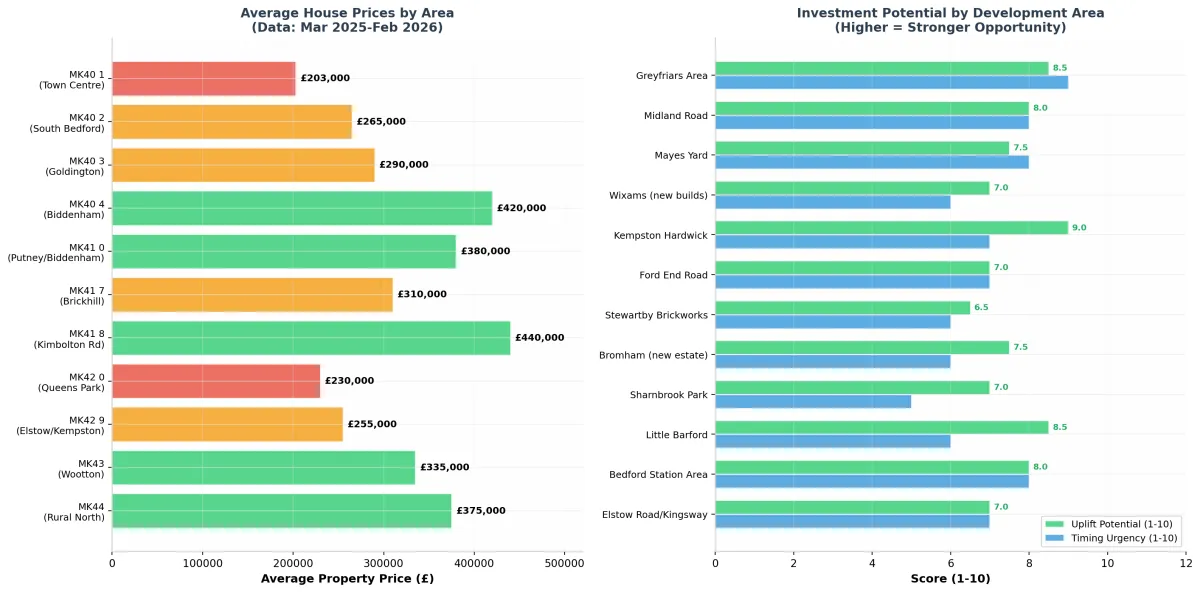
Town centre regeneration investment scores
From the property analysis data (Mar 2025–Feb 2026). Higher = stronger opportunity.
| Area | Uplift potential (1–10) | Timing urgency (1–10) | Assessment |
|---|---|---|---|
| Kempston Hardwick | 9.0 | 8.5 | Highest rated — Universal proximity |
| Greyfriars Area | 8.5 | 8.5 | Active SPD, 500 homes pipeline |
| Little Barford | 8.5 | 6.0 | EWR new settlement; longer horizon |
| Bedford Station Area | 8.0 | 8.0 | EWR trigger, strong timing |
| Midland Road | 8.0 | 8.5 | Active works, quick wins |
| Mayes Yard | 7.5 | 8.0 | Brownfield, central |
| Bromham (new estate) | 7.5 | 6.0 | Under construction, good amenities |
| Wixams (new builds) | 7.0 | 6.0 | Station opening 2026 is catalyst |
| Ford End Road Area | 7.0 | 6.5 | Allocation, mid-term |
| Sharnbrook Park | 7.0 | 4.5 | Neighbourhood plan, longer lead |
| Elstow Road / Kingsway | 7.0 | 6.5 | Urban extension, good fundamentals |
| Stewartby Brickworks | 6.5 | 6.0 | Part of Universal site |
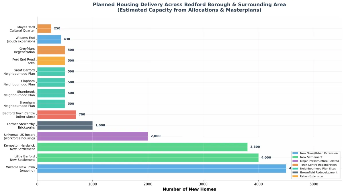
Major Housing & Mixed-Use Allocations (Bedford Borough)
| Site name | Location | Homes | Status | Developer / App ref | Key roads affected |
|---|---|---|---|---|---|
| Wixams New Town (Villages 1–4) | A6 south of Bedford / Central Beds border | 4,500+ (phased to 6,000) | Construction | Bloor Homes, Taylor Wimpey, Barratt; multiple BBC/CBC refs | A6, Bedford Rd, Ampthill Rd, Station Rd (new Wixams stn) |
| Wixams End (south expansion) | Land South of Wixams, adj. Wilstead | 375–430 | Outline submitted | Wates Developments; ref 24/02463/MAO (BBC) | A6, Watson Road, Green infrastructure corridors |
| Kempston Hardwick New Settlement | Adjacent to Universal site, south Bedford | ~3,800 | Draft allocation LP2040 | TBC; LP2040 Policy | Bedford Rd, A421 corridor, new EWR station access |
| Little Barford New Settlement | NE Bedford, near A1/EWR intersection | ~4,000 | Draft allocation LP2040 | TBC; LP2040 Policy (on EWR/A421 corridor) | A421 (new dual), A1, EWR new station |
| Great Barford (Land west of village) | Great Barford, north-east of Bedford | ~500 | Pre-application | Axiom Developments; LP2030 Policy H1 allocation | Bedford Road, village access roads |
| Land West of Wootton | Wootton, SW of Bedford | Multiple phases | Phases ongoing | Various; refs 13/00016/MAO, 16/00001/MAF | Cranfield Rd, A421, Wootton village roads |
| Bromham Road / Biddenham Garden Village | West of Bedford, Biddenham | ~500 (Neighbourhood Plan) | Consented / building | Various housebuilders; search "Biddenham Garden Village" | Bromham Rd, Biddenham Loop, A428 corridor |
| New Cardington / Shortstown | SE of Bedford, former RAF Cardington | Multiple phases | Part complete | Various; reserved matters ongoing around hangars | Cardington Rd, Cotton End Rd, Station Rd |
| Colworth Garden Village | North Bedford, near Sharnbrook | Allocated (draft) | Draft LP2040 | Unilever / landowner-led | A6 north, Sharnbrook Rd |
| Renhold Park / Kings Wood | NE Bedford (Kelly's Field) | ~800 | Phase 1 delivered | Kelly Family; 2013 consent | Renhold Rd, Ravensden Rd |
| Sharnbrook Neighbourhood Plan sites | Sharnbrook village, north Bedford | ~500 | NP allocation | Various small developers | High Street, Manor Rd, Odell Rd |
| Merchant Quay (Riverside) | Town centre riverside | Mixed-use | Complete | Ref 15/00011/MAF (cinema, hotel, restaurants) | Embankment, Newnham Rd, The Riverside |
Transport & Infrastructure Plans
Tempsford New Town (12 miles from Bedford)
Government shortlisted March 2026 — up to 40,000 homes
Tempsford is one of seven new towns shortlisted by the UK Government's New Towns Taskforce in March 2026. The proposed settlement of up to 40,000 homes would sit at the intersection of the East Coast Main Line and East West Rail, between Sandy and St Neots, approximately 12 miles from Bedford town centre. A village of ~400 people could become a settlement of 100,000+ residents. Development Corporation delivery mechanism proposed.
- Location: between Sandy and St Neots on the A1/East Coast Main Line corridor
- Key driver: intersection of ECML + EWR creating a major public transport hub
- Proposed new station at Tempsford on both ECML and EWR
- Flood risk from Rivers Great Ouse and Ivel — major constraint to address
- Government consultation on New Towns Programme: Spring 2026
- Delivery body: Development Corporation (government overseen) proposed
- Planning authority: Central Bedfordshire Council (majority of site)
| Item | Detail |
|---|---|
| Status | Government shortlisted March 2026; public consultation ongoing Spring 2026 |
| Homes proposed | Up to 40,000 (largest of the 7 new town proposals) |
| Employment | 230 hectares research/commercial; life sciences focus (lab space) |
| Rail | New station on ECML + EWR intersection; Tempsford EWR station fast-tracked target by 2030 |
| Road | A421 dualling (now under construction) improves Bedford–Tempsford connectivity; A1 south of Black Cat also flagged for improvement |
| Flood risk | Rivers Great Ouse (west) and River Ivel (east) present significant constraints; linear settlement design proposed |
| Delivery | Development Corporation with planning and land assembly powers proposed; requires upfront government infrastructure funding |
| Nearest LPA | Central Bedfordshire Council; centralbedfordshire.gov.uk/planning |
| Distance from Bedford | ~12 miles north-east |
20-Mile Radius — Key Developments by Neighbouring Authority
Central Bedfordshire
- Wixams (south half) — 6,000 homes total with BBC
- Marston Vale new villages — 5,000 homes (two villages, north of Lidlington)
- Stewartby — part of Universal site; adjacent regeneration
- Ampthill / Flitwick urban extensions
- Cranfield — 63 homes + aeronautical park expansion
- Aldi & B&M distribution centres (Wixams industrial)
- Tempsford New Town (shortlisted 2026)
- Alconbury Weald / Huntingdon fringe (north border)
Milton Keynes City
- MK East strategic site — major eastern expansion
- MK:U new university campus
- CMK (Centre:MK) expansion & renewal
- Eastern Expansion Area (Campbell Park area)
- MK renewed town vision — 40,000 homes extension (new towns shortlist 2026)
- EWR connection at Bletchley — major interchange
- Silverstone motorsport cluster (18 miles SW)
Huntingdonshire
- Alconbury Weald — 5,000+ homes, major enterprise park
- St Neots eastern expansion — 3,000+ homes
- Tempsford New Town (straddles CBC/HDC boundary)
- St Neots — improved A428 Cambridge Road junction (2027)
- Buckden, Brampton — neighbourhood plan sites
North Northamptonshire / West Northants
- Rushden Lakes & Rushden urban growth
- Northampton Waterside (Northampton Railway Station quarter)
- Wellingborough regeneration (Stanton Cross — 3,000+ homes)
- Kettering north-east urban extension
- A45 corridor improvements
South Cambridgeshire
- Cambourne — ongoing completion, EWR new station planned
- Bourn Airfield — 3,500 homes new village (under construction)
- Northstowe — 10,000 home new town
- Cambridge Biomedical Campus expansion
- EWR Cambridge East station (subject to funding)
Luton Borough
- Luton Airport expansion (DART people mover operational)
- Napier Gateway regeneration (mixed-use)
- Luton Town Centre Heart regeneration
- Power Court mixed-use development
- Hat District / creative quarter
Bedford Borough Rural (within BBC area)
- Oakley — small allocations (~50 homes neighbourhood plan)
- Bromham — new estate (~500 homes NP)
- Sharnbrook — Sharnbrook Park and NP sites
- Clapham — 500 homes NP allocation
- Great Barford — 500 homes (LP2030 allocation)
- Ravensden — small allocations
Warner Bros. Studios Leavesden
- Located in Three Rivers District / Watford border — NOT in Bedford area
- Expansion underway: new sound stages, workshops, PV energy
- 86% carbon reduction target; BREEAM Excellent
- Ref: Watford BC planning; Three Rivers DC
- Note: Harry Potter Studio Tour IP rights prevent Universal (Bedford) from using HP
Street-Level Impact Index — Bedford Town & Surrounds
| Street / Road / Area | Ward / Location | Project / Use | Type | Status |
|---|---|---|---|---|
| Station Road (Bedford Midland) | Town centre | Station Quarter regeneration; EWR gateway; new public plaza | RegenTransport | Masterplanning |
| Union Street / Greyfriars Road | Town centre west | Greyfriars regeneration (500 homes); police station 105 flats (ref 21/01680/OUT); junction signalisation | RegenHousing | SPD adopted; outline permission |
| Midland Road (A6 — town section) | Town centre | Corridor improvements: shopfronts, narrowed carriageway, street furniture, new signals | RegenPublic realm | Active works 2026 |
| St Paul's Square | Town centre | Public realm upgrades, performance/events space | Public realm | Phase 1 complete |
| The Embankment / Riverside | Town centre south | Riverside Bedford (cinema, hotel, restaurants) — complete. Further public realm on Great Ouse | RegenPublic realm | Complete (cinema etc.); further phases planned |
| Harpur Street / High Street | Town centre | Harpur Centre retail; shopfront heritage grants; BID improvements | Public realm | Rolling programme |
| Beverley Crescent / Hurst Grove | Putnoe / Queens Park | New 3m ped/cycle link to Bedford station (Towns Fund) | Active travel | Under construction |
| Bromham Road (junction) | Bedford west | New signalised junction as part of cycle link to station | Transport | Under construction |
| Castle Road (gyratory) | Queens Park | Footway widening, new cycle lane on gyratory | Active travel | Under construction |
| Dame Alice Street / Harpur Street | Town centre | New cycle path, pedestrian crossings (Towns Fund) | Active travel | Under construction |
| Barkers Lane Roundabout | Brickhill | New zebra crossing, path widening, active travel improvements | Active travel | Under construction |
| Woburn Road / Alexandra Road | Station south | Station access improvements: resurfacing, lighting, cycle access | Transport | Under construction |
| Rothsay Road (gyratory) | Town centre west | Crossing upgrades (pedestrian safety) | Active travel | Under construction |
| Bedford Road / Kempston Hardwick | SW Bedford | Universal UK Resort access; A421 slip roads; Broadmead Rd junction signal | UniversalRoads | SDO approved; construction starting |
| Broadmead Road | Stewartby / Kempston Hardwick | Permanent signalisation (Woburn Rd junction); construction traffic; width constraints flagged | UniversalRoads | In design |
| Manor Road (east) | Kempston Hardwick | Enabling works access; possible temporary closure during peak construction; NR bridge | UniversalRail | Agreed in principle |
| Ampthill Road | Wixams / Kempston Hardwick | Moderate vibration impact zone during Universal construction; resident mitigation required | Universal | Mitigation in planning |
| Green Lane (Stewartby area) | Stewartby | Active diversions July 2026 — underground services survey for Universal | Universal | Active diversions NOW |
| A6 (Bedford to Wixams) | South Bedford | Wixams new town access; Wixams station access; increased HGV during construction | HousingTransport | Ongoing |
| Bedford Road (Great Barford) | NE Bedford | 500-home LP2030 allocation (Axiom); pre-application 2024 | Housing | Pre-application |
| Cranfield Road / Wootton | SW Bedford | Land West of Wootton — multiple housing phases | Housing | Phase 1 complete; ongoing |
| Cardington Road | SE Bedford | New Cardington / Shortstown mixed-use (former RAF Cardington) | Housing | Part complete, ongoing |
| A421 (Bedford to Black Cat) | East Bedford / A1 junction | Continues as dual carriageway after Black Cat; new Tempsford EWR station access to be added | RoadsRail | Partly complete; EWR additions TBC |
| A428 (St Neots to Black Cat) | East of Bedford | New 10-mile dual carriageway; renumbered A421; Cambridge Road junction improved for St Neots | Roads | Under construction — Spring 2027 |
House Prices by Postcode Area (Mar 2025–Feb 2026)
| Postcode | Area | Average price | Relative position | Investment context |
|---|---|---|---|---|
| MK40 1 | Bedford Town Centre | £203,000 | Lowest | Greyfriars/Station regeneration should uplift; entry opportunity |
| MK42 0 | Queens Park / Kempston | £230,000 | Active travel improvements; Universal proximity to south | |
| MK42 9 | Elstow / Kempston | £255,000 | Wixams spillover; close to Universal site — watch closely | |
| MK40 2 | South Bedford | £265,000 | Station access; Greyfriars uplift | |
| MK40 3 | Goldington | £290,000 | Good schools area; steady demand | |
| MK41 7 | Brickhill | £310,000 | Green Wheel route improvements nearby | |
| MK43 | Wootton / Kempston Hardwick | £335,000 | Universal site proximity — highest near-term growth potential | |
| MK44 | Rural North Bedford | £375,000 | Village character; Tempsford watch for spillover | |
| MK41 0 | Putney / Biddenham | £380,000 | Biddenham Garden Village; premium west Bedford | |
| MK40 4 | Biddenham | £420,000 | Premium area; new garden village housing | |
| MK41 8 | Kimbolton Road | £440,000 | Highest | Top Bedford residential corridor |
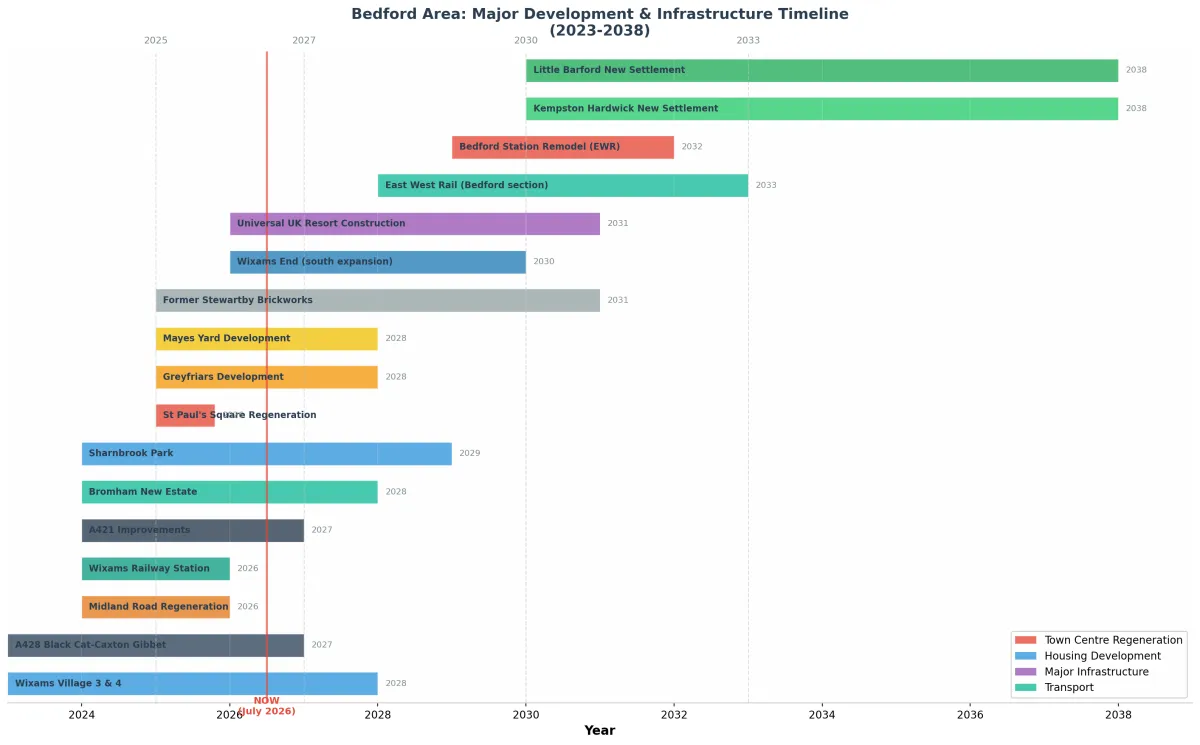
Development & Infrastructure Timeline (2024–2038)
Complete URL & Document Directory
Bedford Borough Council — Planning & Policy
Universal Studios UK
East West Rail
Roads — National Highways
Housing developments
Neighbouring planning portals
Tempsford New Town
Town Centre & Regeneration
How to Get a Real-Time Street-by-Street View
Three tools give you every single street, parcel by parcel
- Bedford planning map: Go to planning.bedford.gov.uk/Planning/ → "View and comment on planning applications" → "Search by map". Pan to any road, set a date range (e.g. last 5 years), and every submitted application appears as a pin. Click any pin for all documents: site plans, elevations, transport assessments, design & access statements, S106 agreements.
- Interactive Policies Map: ArcGIS viewer shows Local Plan allocations, zones, designations, constraints, and conservation areas — toggle layers to see exactly what's permitted or allocated on any individual plot.
- Brownfield Land Register: bedford.gov.uk/brownfield-register — all identified PDL sites with addresses, areas, and indicative capacity. Cross-reference with the map to spot opportunity sites not in the main plan.
For the 20-mile radius outside Bedford Borough
- Each neighbouring council has its own planning portal map — linked in Section 11
- Use planningportal.co.uk as a single-search entry point for any English LPA
- Use infrastructure.planninginspectorate.gov.uk for all NSIPs (Universal, EWR, A428)
Local Plan status — important note (July 2026)
Bedford Borough's Local Plan 2040 was withdrawn from examination in October 2025. The council is now starting a fresh Local Plan 2050 process (target adoption November 2029). In the interim, planning decisions are being made on a patchwork of policies dating to 2002, creating risk of speculative and uncoordinated development — but also creating planning opportunity where pre-allocation sites may gain permission through alternative routes. Always check the current development plan status before any site assessment.
| Task | Best tool | URL |
|---|---|---|
| Find every planning app on a specific street | Bedford Planning Map (map search) | planning.bedford.gov.uk/Planning/ |
| See what's allocated in the Local Plan for a plot | Interactive Policies Map | bedford-borough.maps.arcgis.com |
| Find previously developed land / brownfield sites | Brownfield Land Register | bedford.gov.uk/brownfield-register |
| Universal Studios documents (masterplans, transport) | Bedford BC major developments page | bedford.gov.uk/universal-studios |
| EWR route maps and safeguarding plans | EWR maps library | eastwestrail.co.uk/library/maps |
| A428 scheme maps and construction updates | National Highways A428 page | nationalhighways.co.uk/a428 |
| Planning in Central Beds (Wixams, Marston Vale) | CBC planning portal | centralbedfordshire.gov.uk/planning |
| Neighbourhood plan sites & allocations | Individual parish NP documents on Bedford portal | bedford.gov.uk/neighbourhood-planning |
Bedford Borough Planning & Regeneration Intelligence Report — Compiled July 2026 for Linden Fairbridge Advisory Limited. Data drawn from: Bedford Borough Council, Central Bedfordshire Council, MHCLG GOV.UK, East West Rail Co, National Highways, Planning Inspectorate. Always verify current planning status at live portals before making investment decisions. This report is a research summary — not legal or financial advice.